Princeton To Redraft Housing Element; May Need Many More Affordable Homes

Affordable housing at Princeton Community Village, off Bunn Drive. (click to expand)

Affordable housing at Princeton Community Village, off Bunn Drive. (click to expand)

Shirley Bishop, an expert in affordable housing, advised Princeton Council last week that the town was not in imminent danger of a “builder’s remedy” law suit. She was speaking in light of a NJ Supreme Court ruling that gave the Superior Court control of affordable housing quotas. But the town must update the ‘Housing Element’ of the community Masterplan by November, and it may be necessary to increase the number of planned affordable dwellings. Continue reading

Posted in Affordability, planning, Zoning | Tagged , , | Leave a comment

TBT: When Princeton Nearly Said “No” To Michael Graves

The Paul Robeson Center for the Arts in Princeton is a distinctive Michael Graves design. But the building was the source of controversy for years. (click to expand)

The Paul Robeson Center for the Arts in Princeton is a distinctive Michael Graves design. But the building was the source of controversy for years. (click to expand)

This week has seen many tributes to local architect Michael Graves, who died last Thursday at the age of 80. An internationally recognized force in the post-modern architectural movement, Graves was a true legend. The local media are full of praise this week, but the reaction to Graves’s only major public building in Princeton was a lot more mixed. When Graves offered his services to design a new home for the Princeton Arts Council at the intersection of Paul Robeson Place and Witherspoon Street (see image above), the Planning Board returned a simple answer: “No”. It took years, multiple revisions, and significant down-sizing before the building that currently stands was approved.

Continue reading

Posted in architecture, Downtown Vibrancy, People, Placemaking, planning, Princeton, The Parking Question, Zoning | Tagged , , , | Leave a comment

Is A Historic District Designation The Right Choice For Witherspoon-Jackson?

Homes on John Street in Princeton, which is slated to become a historic district. (click to expand.)

Homes on John Street in Princeton, which is slated to potentially become a historic district. (click to expand.)

At the Witherspoon-Jackson Neighborhood meeting last Saturday, local residents heard details of a proposal to apply for ‘historic district’ status for the area around John Street in Princeton. If this application is successful, the Witherspoon-Jackson area would become the fifth officially-recognized historic district in Princeton. The designation would mean that homeowners in the historic district would have to request permission from the Historic Preservation Commission any time they wanted to make modifications to their properties. A similar proposal to obtain historic district designation for the so-called ‘Morvern Tract’ in Princeton’s Western Section was shelved in 2012 after objections from residents. Would historic district status be more appropriate for the Witherspoon-Jackson neighborhood? Continue reading

Posted in Affordability, Community, Placemaking, Princeton, Sustainability, Zoning | Tagged , , | 3 Comments

Princeton Environmental Film Festival Highlights To Include Movie About Walkability

Princeton Public Library, venue for the screening of 'The Walking Revolution' at the 2015 Princeton Environmental Film Festival. (click to expand.)

Princeton Public Library, venue for the screening of ‘The Walking Revolution’ at the 2015 Princeton Environmental Film Festival. (click to expand.)

The ninth Princeton Environmental Film Festival is just about to start up, and as usual, promises some great shows for local residents who are interested in sustainability issues. This year’s program starts Friday night, March 13, at 7 p.m. with ‘Climate Change Cabaret‘ featuring a jazz band and vocal performances. Like all PEFF events, it is free! Walking is of course the ultimate low-carbon activity, and if you’re interested in how to make walking an easier part of everybody’s lives, you won’t want to miss a movie that is showing on Tuesday, March 24! ‘The Walking Revolution‘, produced by non-profit ‘America Walks‘,  will be shown in its entirety as part of the festival, with an expert panel fielding questions and discussion afterwards! Continue reading

Posted in Events, Princeton, Sustainability, Walking | Tagged , , , , | Leave a comment

Princeton-Area Municipalities Face Scramble To Prove Affordable Housing Compliance

Affordable homes at Princeton Community Village, off Bunn Drive. (click to expand).

Affordable housing at Princeton Community Village, off Bunn Drive. (click to expand).

In a historic ruling today, the New Jersey Supreme Court gave a unanimous judgement that the State’s key affordable housing task force, the Council on Affordable Housing, has become dysfunctional and is no longer fit for its purpose. The Supreme Court has put all municipalities on notice that they must prove their compliance with their constitutional requirement to provide a fair share of affordable housing, or allow builders to add affordable housing under the supervision of the courts. How will this ruling affect Princeton? Continue reading

Posted in Affordability, Local, planning, Princeton, Smart Growth, Zoning | Tagged , , , | 1 Comment

Making Maps Of Princeton’s Parks And Trails Online

Scenic beauty in Princeton's  Woodfield Reservation, April 13, 2014. (click to expand.)

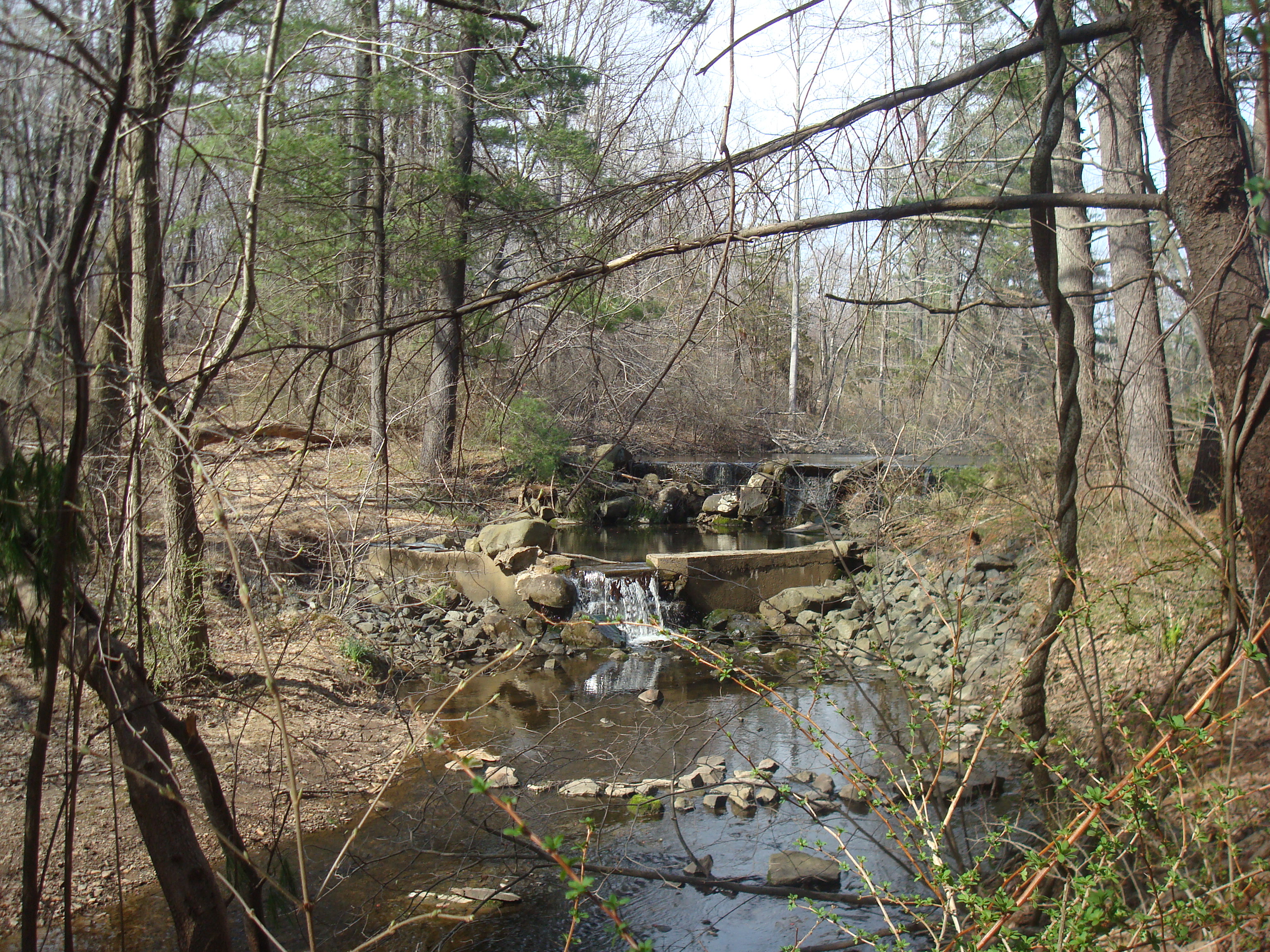
Scenic beauty in Princeton’s Woodfield Reservation, April 13, 2014. (click to expand.)

In Princeton, we have amazing parks and preserved open space, but what’s the best way to explore it all? Many trail maps are hard to find, and there is no single place where you can find them all together. Google Maps offers a solution, because it includes many trails. On the other hand, a lot of trail information is missing. But it is relatively easy to add trails in ourselves…

Newly-annotated trails in Herrentown Woods, in north-east Princeton. (click to expand).

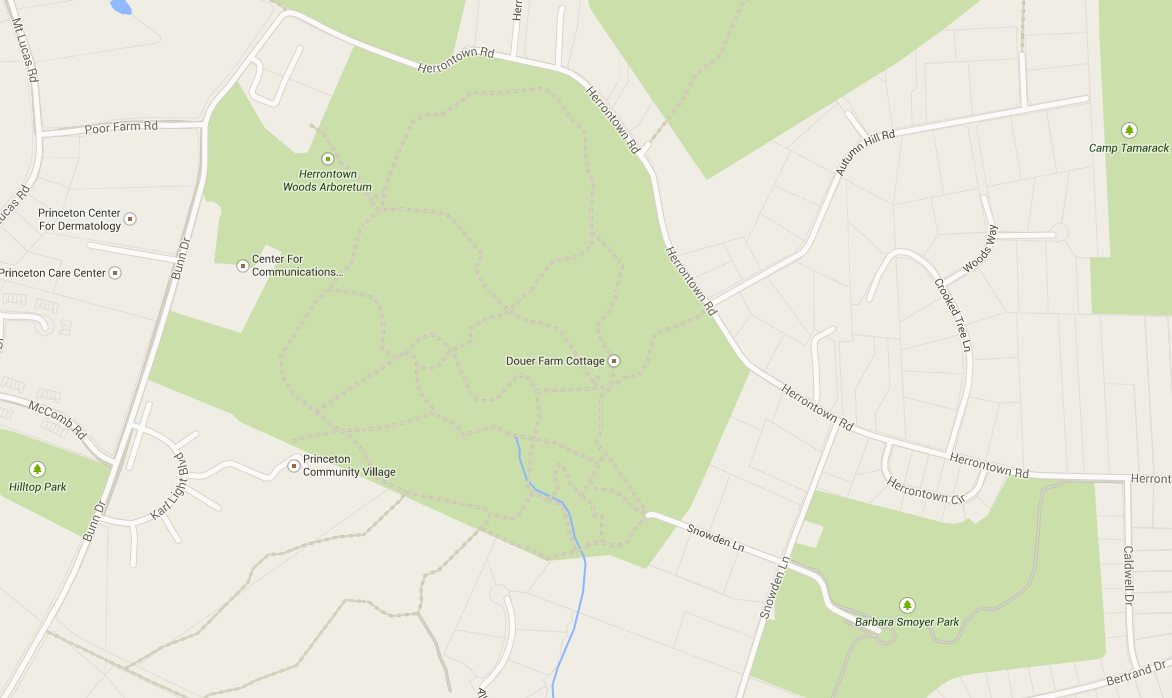
Newly-annotated trails in Herrentown Woods, in north-east Princeton. (click to expand, or click here to see a scrollable map at the Google Maps website).

Winter of 2014-2015 has been the coldest since 1994, with enough snow and ice to make enjoying local parks a challenge. I’ve been spending more time than I’d like to indoors, and some of that time has been dedicated to adding local trails onto Google Maps. For example, the trails in Herrentown Woods (see above), Gulick Farms, and open space east of Kingston were all added by me this winter. I went around all these trails last year, and saved the routes using a GPS device. (Many devices allow GPS mapping, including most smartphones). Adding the trails onto the online map makes me happy, knowing that it may help others discover these beautiful natural areas, and explore them on foot. It’s a work in progress, and many of the trails are still incomplete or need to be corrected.

This is where you might want to join in. You, too, can add trails (or any other map info) onto Google Maps*. Go to ‘Google MapMaker‘, log in, and use the point and click tools to draw trails onto the map, add on to existing trails, or edit other map data. The interface is a bit clunky, but my guess is that Princeton people are smart enough to figure it out.

Screenshot of Google MapMaker interface. (click to expand).

Screenshot of Google MapMaker interface. (click to expand).

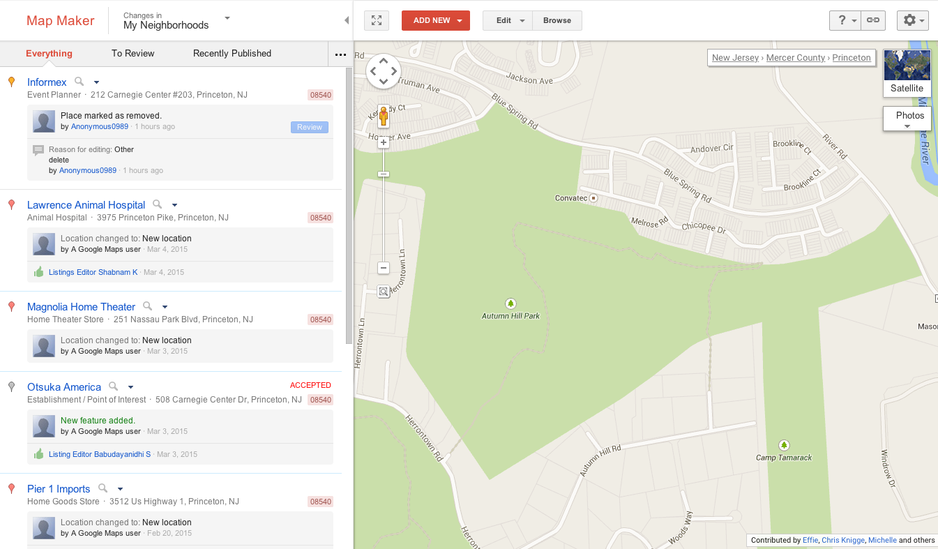
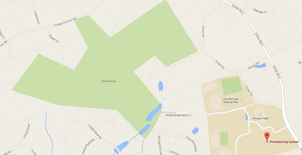
After you make edits, you will probably have to wait until another user ‘approves’ your edit before it appears on the official Google Maps. This is slightly annoying but necessary to stop spammers and abusers from putting useless data onto the system. The more editors we have in Princeton, the quicker we can collaboratively get changes approved, and add all our local knowledge. Right now, the quality of the map data is very variable. Some places, such as Princeton University campus, have loads of detailed info. Other places have almost no data, or very poor data. For example, the trails in Woodfield Reservation are completely missing, and the entire 100-acre park is currently tagged only with the words ‘Stony Brook’:

One of Princeton's largest open space areas, the Woodfield Reservation, isn't even labeled correctly on Google Maps at the time of writing. (click to expand)

One of Princeton’s largest open space areas, the Woodfield Reservation off Great Road, isn’t even labeled correctly on Google Maps at the time of writing. (click to expand)

Some maps of local parks are online already – if you can find them. But Google Maps has several advantages. First, you can use online tools to easily calculate distance and walking time between two points. This can be hard using traditional maps. Second, while walking, a trail user can use a smartphone to check their position against the online map. This makes it much harder to get lost when exploring an unfamiliar park or trail network. We have a pretty amazing amount of open space in Princeton. Let’s make it easily accessible to the greatest possible number of people.

* Some of you reading this may be saying, ‘why not use OpenStreetMap instead’? I totally hear you, and encourage you to use whatever mapping application you most prefer.

Got a favorite park or open space area in Princeton? Let us know in the comments section below.

Posted in Princeton, Walking | Tagged , , , | Leave a comment

Princeton’s Affordable Housing Task Force Checks In

The Princeton First Aid And Rescue Service are due to relocate to Valley Road and route 206, leaving this site on North Harrison Street as a potential location for affordable housing. (click to expand).

Princeton First Aid And Rescue Service are due to relocate to  Valley Road, leaving their current site on North Harrison Street as a potential location for affordable housing. (click to expand).

At Princeton Council last week, Council President Bernie Miller presented an interim report on the work of the ‘Affordable Housing Task Force’. This task force was set up in September 2014, as the town was considering whether to use two newly-acquired pieces of land to build new affordable housing. Miller, along with Council members Crumiller and Liverman are involved in the task force, along with representatives of Princeton’s Affordable Housing agencies and several citizen volunteers. How are they getting on?

Continue reading

Posted in Affordability, People, planning, Princeton | Tagged , , , | Leave a comment

Princeton Council Does The ‘Hokey-Pokey’ On Complete Streets In Bike Lane Vote

Princeton Council is giving mixed signals on commitment to 'Complete Streets'. (click to expand)

Princeton Council is giving mixed signals on commitment to ‘Complete Streets’. (click to expand)

Last week, Princeton Council indefinitely put off making a decision about adding repurposing on-street parking to make a safe bike facility on part of Hamilton Lane. Although several Council members argued that they would potentially be open to the idea of adding the bike lane at a later date, the move calls into question Princeton’s commitment to making roads safe for all users. Continue reading

Posted in Alternative Transportation, Complete Streets, Princeton, The Parking Question, Traffic | Tagged , , | Leave a comment

Should Princeton U. Students Live Off-Campus?

Holder Hall, Princeton University, one of many sites of campus housing for undergraduates (Image credit: Peter Dutton via Wikimedia Commons)

Holder Hall, Princeton University, one of many sites of campus housing for undergraduates (Image credit: Peter Dutton via Wikimedia Commons)

Should Princeton University undergraduates have an off-campus housing experience? That question is raised in a great piece by Steve Swanson in ‘The Daily Princetonian’  (‘Temporary Utopia’, read the full article here). Potentially, living in non-college housing would offer students a chance to gain valuable independence. Continue reading

Posted in Affordability, Community, Princeton | Tagged , , | 1 Comment

Will Princeton Build Bike Lanes? And If So, Where?

hamilton

Hamilton Avenue project zone near North Harrison Street in Princeton. Note cyclist on sidewalk, an indication that cyclists do not find the street suitable for safe riding. (click to expand, via Google Streetview).

An interesting debate is underway in Princeton about whether the town should add bike lanes. Around a dozen people showed up to Council in January to support the introduction of an ordinance to repurpose on-street parking for bike lanes on part of Hamilton Avenue. Last night, about a dozen people spoke against the plan at a neighborhood meeting. But the opposition was not unanimous, and letters columns in local papers are filling up with arguments from both sides. Princeton Council is set to vote on the matter next Tuesday, February 24. They will have to weigh the costs and benefits, and consider their own policy on ‘Complete Streets‘.  Continue reading

Posted in Alternative Transportation, Complete Streets, planning, Sustainability, The Parking Question | Tagged , , , , | 3 Comments