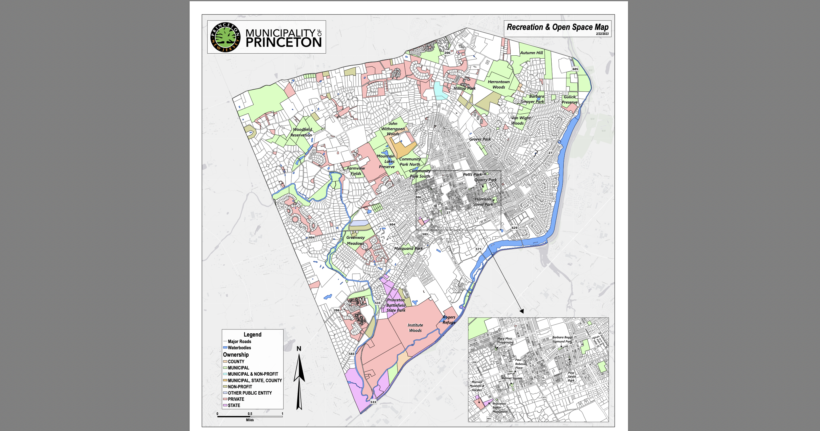
The town of Princeton has acquired large amounts of open space in recent years, but until very recently, there was no publicly-accessible map of protected lands. Speaking to the Princeton Environmental Commission on Feb 22, municipal open space manager Cindy Taylor unveiled a new map, showing the locations of every tract in the town that is subject to conservation orders.
27% of land in the town of Princeton has some kind of regulatory protection to prevent development. The kinds of protections vary. Some land is open space owned by the town, such as Community Park North. Other land is owned by Mercer County, or the State of New Jersey, such the Princeton Battlefield State Park. A suprisingly large amount of local open space is privately-owned, but cannot be developed because of conservation easements or rules relating to cluster developments. This includes the ‘Coventry Farm’ land off Great Road, and a number of parcels around Ridgeview Road in the Princeton Ridge area.
The Open Space map has been prepared as part of a town effort to update its “Environmental Resource Inventory”. Last updated in 2010, the Enviromental Resource Inventory serves as a catalog and analysis of natural resources in the town. Ms. Taylor introduced a consultant, Ryan Gibson, from Ecotone, Inc, who have been recruited to carry out the work. Mr. Gibson explained the process, which has included collecting all data on existing open space holdings. In the near future, the consultants will do field work to inspect plants and wildlife in open space areas, and review recent climate data.
Mr. Gibson noted several challenges facing Princeton open space. Although the town has collected a large area of land, most of the land is riddled with invasive species, which are very challenging to eliminate. Public accessibility to many of the open spaces is limited, and no good trail map exists for many areas. Despite these challenges, Council seems keen to add more land to the town’s inventory of open space. At their meeting on Feb 13, Council agreed to purchase 34 more acres of privately-owned open space off Cherry Valley Road, and a recent closed Council session focused on potential further open space acquisitions.
The new Environmental Resource Inventory will also consider where “open space deserts” exist in Princeton. These are defined as areas more than half a mile from existing open spaces. A glance at the map shows that most open spaces in Princeton are located in the wealthy areas around Princeton Ridge and in the Western part of town. The Princeton municipal website has further information about the process of updating the Environmental Reserouce Inventory (see links below), and public comment is welcome through this Wednesday, March 8, by e-mailing engineering@princetonnj.gov.
Relevant links:
Environmental Resource Inventory information page (via princetonnj.gov)
