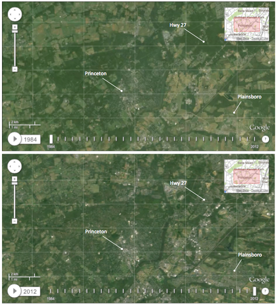
Top – Princeton from Landsat imager 1984. Bottom- Princeton as seen by Landsat in 2012. (Click for larger image)
Last week, Google made available an astonishing resource, which enables us to review satellite imagery of anywhere in the US on an annual basis from 1984 through 2012. You can read about the project here. They were able to make some amazing images, showing, for example, how the Columbia Glacier in Alaska has retreated in the face of rising global temperatures (click the previous link for an animated GIF).
We were obviously interested to see how Princeton has changed since 1984. You too, can view the timelapse satellite imagery, which we have linked to here. We encourage you to do so– it is amazing to see how Princeton has changed. Actually, the town of Princeton itself does not show many visible differences, although the eagle-eyed may spot some changes, such as the redevelopment of the Princeton University stadium in 1998, which is plainly visible. (Note: high-magification images like those used in present-day Google Maps are not available from 1984, so the images are unfortunately pretty grainy.)
Outside of town, however, there are huge differences. Whereas Princeton in 1984 was encircled by farmland and open space, in 2012 the landscape appears different. Look at the fields to the north and northwest of Princeton town. Instead of the solid green in 1984, they now appear mottled with gray and brown. Why is this? Because those open fields and woodland have been replaced by houses. In fact, all around Princeton, we see a pattern of brown-y gray replacing the greens seen in 1984.
To pick one striking example, along Highway 27 (Lincoln Highway) in Kendall Park, we see a huge tract of green completely replaced by houses. This is a visual representation of something that was already reflected in the US Census data. Between 1990 and 2000, Kendall Park added almost 2,000 residents; a growth rate of 26.4%. With the satellite imagery, we can watch the homes appearing that these people moved in to. If you look closely while clicking through the years at the Google site, you can even see sandy construction sites appearing, which later become gray as the work is finished.
A second example is around Plainsboro. Again, we see entire tracts of fields being covered with houses. This should come as no surprise. The population of Plainsboro in 1980 was 5,605, whereas now it is estimated as over 23,000. That is a rise of 18,000 people in 30 years! (Princeton took 330 years to increase to its current population of 28,000.)
The growth of population in Mercer County is good news! Whereas other parts of New Jersey are seeing stagnation or Detroit-style population decreases, Mercer is growing thanks to a diversified, knowledge economy that provides jobs for the local population and also draws in people from outside the region. Some of these new arrivals are among the most talented people in the world, highly trained specialists in hi-tech fields, attracted by university-related business.
Why are these people not moving to Princeton, the center of this knowledge economy? Amazingly, as the population of Mercer County grew by 19%, and communities around Princeton grow by even larger percentages, Princeton itself only grew by 11%. Princeton is the only place in the local area showing sub-average growth. Statistics show tens of thousands of jobs in Princeton are being filled by people who live out of town, because Princeton has failed to add homes to match local population growth. Many Princeton residents argue that if any population growth is to happen, it must take the form of low-rise, low-density homes. Reducing the housing supply in this way has led to sky-rocketing house prices in Princeton, leading many people to live elsewhere. Low-rise, low-density homes are exactly what we have been building for decades, and the result is clear: lack of affordability, loss of green spaces, and stifling traffic.

Pingback: Climate Change A Consequence Of Princeton Planning Decisions | walkableprinceton
Pingback: New Plan For Princeton Hospital Site Shows Major Improvements | walkableprinceton