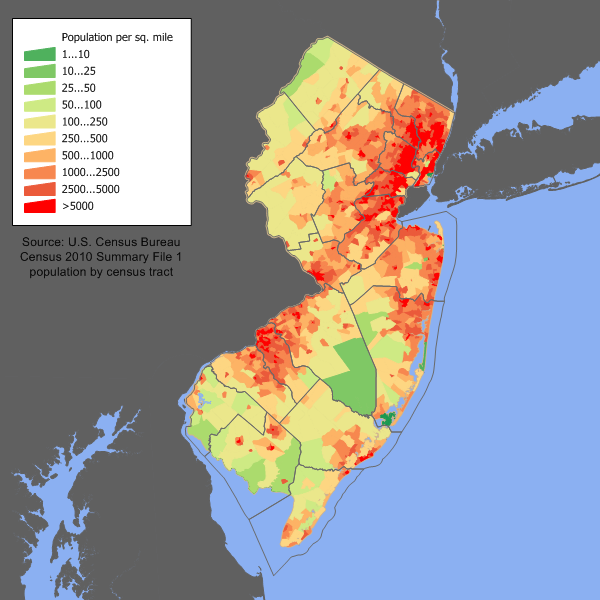
New Jersey has the highest population density of any US state. However, a glance at the population density state-wide (above left, and higher definition version here) shows that we are distributed very unequally. Large areas of the state, most notably around the Pine Barrens, are almost entirely empty. Other parts of New Jersey, such as around Camden, are very dense, reflecting the fact that it is connected to the Philadelphia metro area. The highest density areas in New Jersey are in the north-east part of the state, around New York City. Incredibly, the four densest communities in the USA are in New Jersey. Areas such as Hoboken statistically have a higher population density than NYC itself!
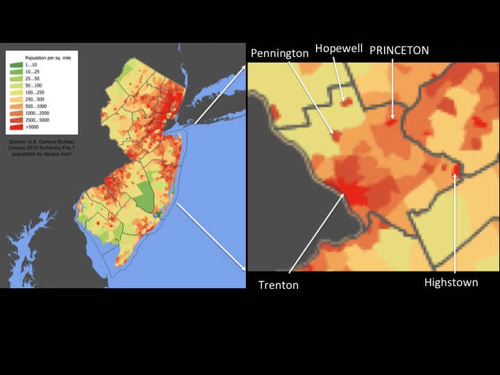
All around NYC, a huge ring of high population density extends, reflecting how the city burst out of its borders and engulfed the surrounding areas in the second half of the twentieth century. The sprawl extends south, through Union and Middlesex counties, with a finger of high-density extending along the Route 1 corridor essentially all the way to Trenton. Here, we find Princeton. Zooming in on Mercer County (above, right), we see that Princeton lies in what is already a fairly urbanized area. Especially to the south around Route 1, we see higher population density, consistent with the rapid development the area has seen in recent decades.
However, not all of the Princeton area is developed. Unlike much of north Jersey, we still see significant areas of relatively undeveloped land around Princeton. To the north, the countryside around Hopewell is still relatively untouched, and to the east, significant tracts of farmland still stand around Plainsboro. Even within the 08540 area, there are areas of undeveloped land, most notably around Cherry Valley Road and Herrontown Road. These areas of undeveloped land are visible as lower areas of population density on the map. They appear as a ‘Thin Green Line’ of unpaved, open space on either side of our town. This open space is incredibly valuable, as a place to get away from the pace of everyday life, as a habitat for our native species and for providing relief to our local watersheds.
The risk now is that we will lose our remaining open space. The population density map of New Jersey shows that the Princeton region is the frontier of development. We must act now, or our area could end up like North Jersey, an endless chain of subdivisions and roadways. Mercer County has seen continuous growth ever since records began in 1840. With the economy in strong state, our population is expected to grow. Where are these people going to live?? We must choose between paving our few remaining green spaces or a more positive, walkable alternative. Many people could live in our downtown areas, including right here in Princeton, within walking distance of stores, bars and workplaces. Others have argued that population density should be kept to a minimum in areas around downtown Princeton. This argument is entirely incompatible with sustainability and conserving our remaining open spaces around Princeton. If we are to be true guardians of our remaining green space, walkable urban development must be favored in place of further low-density, car-dependent growth.
In future posts we will examine how compact, walkable development can enhance our town while protecting the surrounding open spaces.

Agree 100%. Many people say that there is nowhere left to build in Princeton and that we are ‘built-out’ but actually there is still plenty of green space that is worth protecting. As more people move here to take advantage of jobs around Princeton University, we can’t allow all our remaining green space to get paved over the way so much of the state already has been.
P.S. Great blog by the way!
Pingback: Looking For Walkable Solutions | walkableprinceton
Pingback: The Alternative To Walkable Homes In Princeton Is Car-Dependency | walkableprinceton
Pingback: New Plan For Princeton Hospital Site Shows Major Improvements | walkableprinceton