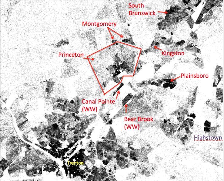
Population density in the Princeton, NJ region. Each dot represents one person. From US Census data. (click to expand.)
Brandon Martin-Anderson of the MIT Media Lab has created a new map showing every person listed in the US Census. This is the most visual exactly where people live throughout the USA. Zooming in on Princeton reveals the exact density of local population and what we see might surprise a lot of people…
Looking region-wide, we can see that despite decades of depopulation Trenton is still by far the biggest town around. However, whereas many people think of Princeton as being significantly denser and ‘city-like’ than other places in the Central Jersey area, that is simply not the case. As can be seen from the dark patches on the map, there is substantial density, equal to or surpassing that in Princeton, in surrounding municipalities. Most notably, Plainsboro is much denser than Princeton, and over a larger area.
The Kingston and South Brunswick areas also contain density equivalent to that seen in Princeton. West Windsor and Montgomery have substantial blocks of density especially right on the border with Princeton.
What’s going on? Simply put, as Princeton has refused to add housing as the region has grown, local municipalities have grown disproportionately quickly, replacing farmland with housing. Unfortunately, most of the jobs are in Princeton, and housing is now too spread out to support efficient transit. That means that the region is choked with traffic. Route 1 can hardly take the volume, leading to frequent tailbacks, and Princeton itself suffers congestion and a scramble for parking that sees significant areas of our downtown used to provide parking for commuters instead of expanded biking and walking trails for local residents.
Zooming in on Princeton explodes the myth that Princeton is ‘becoming a city’. Princeton, where population is not growing, is now just the fourth-largest town in the area, and contains very few areas of significant population density:
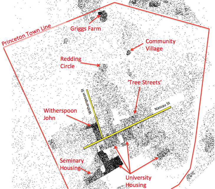
Each dot on this map represents one person from US Census data, hence the dark-shaded areas have the highest housing density. (Click to expand.)
The areas in Princeton with the highest density are mostly the places with student housing. The largest dark-shaded block, corresponding to high population density, is the area where Princeton University residential halls are located. In the town proper, there is only one dense neighborhood, and that is Witherspoon-John. This is interesting, because many people assume that density = tall buildings. There are no tall buildings in the Witherspoon-John neighborhood. The low-rise houses are just relatively tightly packed and sub-divided, providing housing for lots of people in an area close to town. This is not always a good thing, as some people are clearly living in over-crowded conditions in the neighborhood. On the other hand, Witherspoon-John enables people to live close to jobs, and is also served by transit, so it is very likely Princeton’s lowest-carbon neighborhood.
Beyond Witherspoon-John, Princeton doesn’t really have dense neighborhoods. The ‘Tree Streets’ neighborhood, which most people think of as dense, appears to have very moderate density based on Census data. Otherwise, we just have a few small blocks of density, corresponding to individual developments. These include Princeton Community Village, Griggs Farm, and Redding Circle- all of which were affordable housing initiatives. In theory, denser living enables more walkability, but these developments are relatively far from the downtown area. Princeton has got it exactly backwards- we have added density in the least-walkable places, without first adding density in the most central, walkable areas.
Finally, let’s contrast residential density in Princeton with nearby Plainsboro, on the same scale:
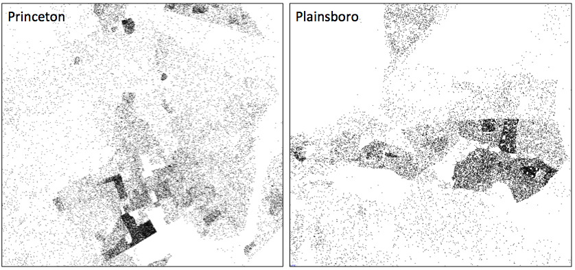
Princeton and Plainsboro. Based on US Census data, one dot equals one resident. Darker areas are therefore the most dense. (Click to expand.)
Setting aside University accommodation, Princeton has fewer areas of dense housing that Plainsboro. This matches the statistics, which show that Plainsboro now has more people per square mile than Princeton. Based on density, Plainsboro is now more of a ‘city’ than Princeton is. Of course this is a ridiculous statement, because Plainsboro is hardly a city. When talking about housing in Princeton, people argue that we can’t possible add new homes for some of the 24,000 people who commute into town daily or ‘we will become a city like Trenton or New Brunswick’. It’s not true. Even if we added 6,000 new residents, Princeton would still have a lower population density than the ‘city’ of Plainsboro.
Please leave your feedback using the comment box below! We’re always interested to hear what you think about our analyses of the local housing and traffic situation!

Pingback: Does Mayor Lempert Really Think That Middle-Class Princeton Workers Should Live In Trenton?? | walkableprinceton
Pingback: Secrets Of Princeton’s Autumn Hill Reservation | walkableprinceton
Pingback: Walkable Housing Helps Local Princeton Businesses | walkableprinceton
Pingback: West Windsor’s Maneely/Toll Brothers Mixed-Use Development In Detail | walkableprinceton